RESULTS
Hypothesis
It was initially believed that majority of gypsum sourced from the edge of the deflation basin (L1 & L2 shorelines) and there were lesser contributions from playa lakes, alkali flats, and Permian formations respectively.
Discovery
Our SAM & LSU images that were overlain with GIS alluvial contacts shows there is no gypsum in the alluvial fans on the East side of the San Andres mountains. This eliminates the Permian formations as a possible active source caused by mountain run-off from summer storms.
Our SAM and LSU images show higher amounts of gypsum in the alkali flats and playa lakes than was originally perceived. This validates the possibility of the alkali flats and playa lakes as larger active sources of the gypsum dunes, which is contrary to the current belief.
In addition, we assessed the integrity of the published geologic formations on GIS, as well as checked the accuracy of our supervised classification algorithms. This was done by overlaying the produced SAM and LSU images from ENVI with known geologic contacts on GIS. Both the SAM and LSU images and GIS formation contacts agreed, which was seen by the GIS alluvial fan contacts precisely following our plotted alluvial fan endmember. The gypsum dune extent in both the SAM and LSU images and GIS formations also agreed. This displayed the accuracy of both the published GIS geologic contacts and the SAM and LSU algorithms used in ENVI. The 6 endmembers: calcite + kaolinite mixture, clay mixture (montmorillonite + illite), gypsum mixture (gypsum, med-high Al muscovite, jarosite), alluvium (hematite + quartz), halite, and gypsum used in SAM and LSU algorithms also agreed with the minerals found in published GIS formation locations. More LSU images can be found on the Gallery page.
This confirms the SAM and LSU images as a more detailed mineralogic map. The SAM map is an easy visualization of all 6 endmembers at once where each pixel is assigned to the endmember with the highest similarity of reflectance angles from 9 bands (70, 71, 72, 147, 148, 149, 203, 204, & 205). The LSU images can better represent the % of the endmembers selected in a RGB color composite image.

Georeferenced Spectral Unmixing showing Alluvial Fans in the Upper and Lower Corner of the hypersepctral data (R: Gypsum, G: Montmorillonite and Illite, B: Hematite and Quartz)
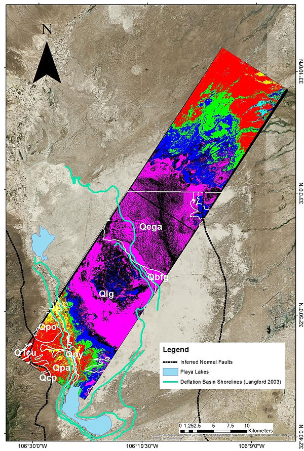
SAM Classification over Study Area with Legend showcasing Deflation Basin Shorelines and Playa Lakes
